whereq.com is open source — the map, the crawler, and everything it reads

A pin is a very small sentence
Stand on a street in Toronto and look at the address in front of you. A map gives you one claim about it: there is a pin here. A coffee shop. A hospital. A school. Maybe a parking garage.
But the place itself is a pile of claims, and the pin is the least interesting one of them.
Which school catchment is that address in? Can I walk to a library, and which one? Is the fuel station on the corner charging 1.79? Is that building inside a ward, or inside a neighbourhood, or in a ward and a neighbourhood? Did anything happen on this street last week?
Every one of those answers is a piece of data, and every one of them lives somewhere else. The school boundaries are in one system, the fuel prices in another, the administrative outlines in a third, the local news in a fourth. The map you are looking at is the result of all of them agreeing.
So I built the part that agrees
The thing that surprised me while building it was how much of the work was not the map at all.
Drawing pins is the easy half. The hard half is that a map is a join. Every layer needs its own key, its own licence, its own rate limit, its own idea of what a place is — and a POI (a point at an address) is not the same thing as an administrative area (a polygon that contains an address), no matter how casually you can slide one into the other.
So the first version of this app had three different ingestion scripts, each one written for its own dataset, each one holding its own API key, each one breaking on its own schedule.
That is the shape of the problem, and it is a shape almost every application in the world has: ten apps, ten scrapers, ten nightly failures.
The fix was to make the retrieval a layer of its own — one process, one cadence, one place where the outside world is allowed to enter the app.
I call it the crawler, and it is the part of this repository I am most pleased with.
The crawler
Everything on the map arrives by being crawled:
- whereq.cloud — fuel stations and their live prices, the aggregated price series, and the administrative geography: provinces, regions, municipalities, cities, towns, wards and neighbourhoods, with their real outlines.
- OpenStreetMap — the places around you. Coffee, food, parking, pharmacies, walk-in clinics, plazas, libraries.
- RSS and JSON feeds — the local news, events, stories and topics that you can switch on in the top-right corner of the map.
One account, one key, one rate limit. The whereq.cloud API allows 30 requests a minute, so the two whereq.cloud crawls share a single throttle — two independent limiters would each allow 30/min and would throttle each other into 429s. It rotates through coverage targets round-robin (a country, a province, a city, a map viewport) so a single tick never asks the upstream for a whole continent, and a target that failed is retried on the next tick rather than waiting out its interval.
The content crawler is the same idea with a parser attached: it discovers
items from the registered sources, normalizes them, extracts the location,
geocodes it through a provider chain, classifies them, and upserts them. A
feed that goes dark records last_status='error' and the crawl carries on.
whereq.com
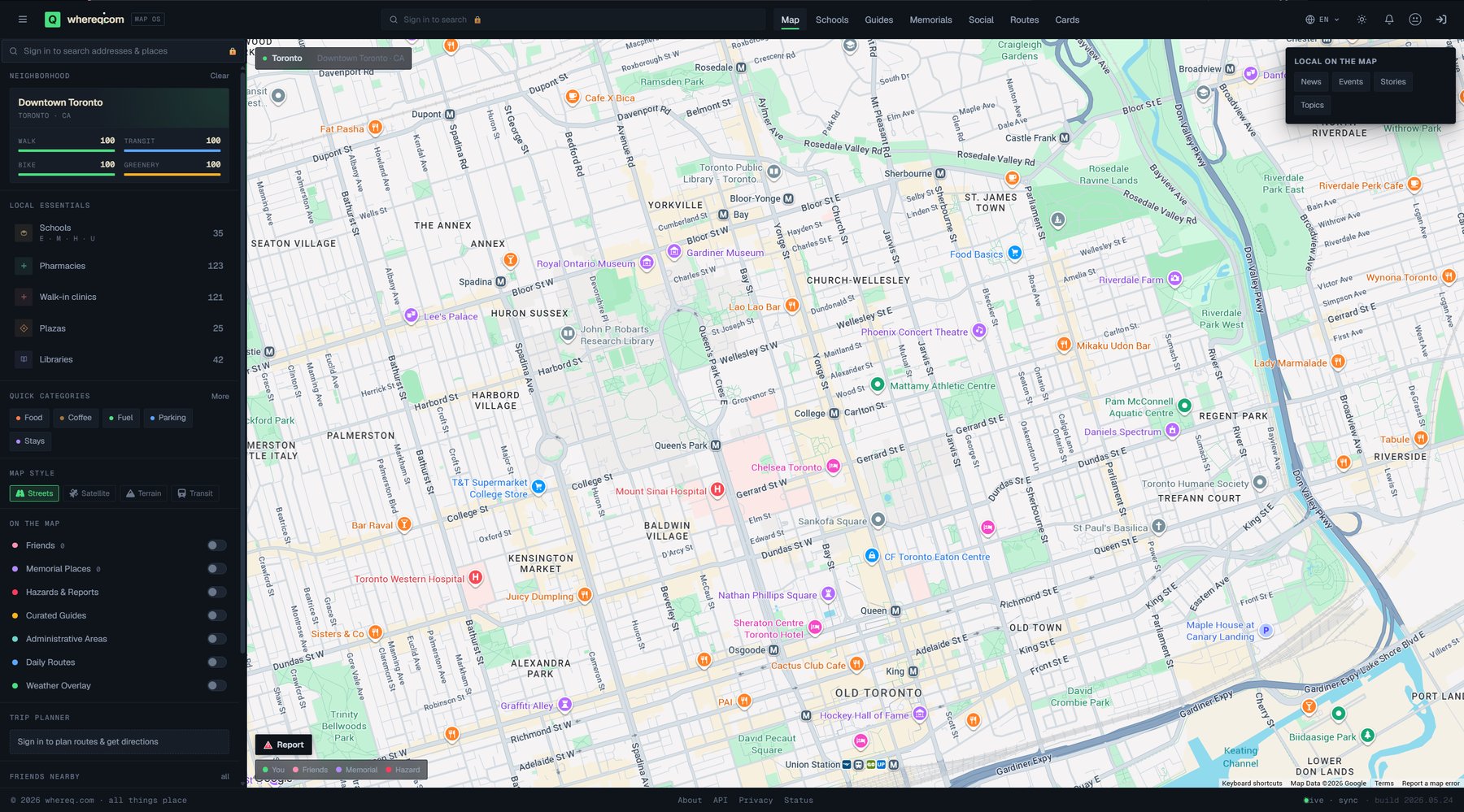
Downtown Toronto. On the left: the neighbourhood guide, the local essentials, the quick categories. Below that: the layers — administrative areas, hazards, curated guides, friends, daily routes. Top right: the content the crawler pulled from the feeds.
whereq.com is a map-centric location platform. Open it and you see the places around you; open any one of them and you get a proper page — address, hours, categories, photos, the route to it, and the notes people left.
Some of what it does today:
- Places and nearby — a POI map, plus a nearby search that merges everything within a radius into one ranked list.
- Place cards — a full page per place, written by people, not by a feed.
- Schools — every school in the coverage area with its catchment boundary, drawn on the map.
- Hazards — environmental and infrastructure hazards, mapped and reported.
- Fuel — stations and live prices, crawled from whereq.cloud.
- Geography — the areas that contain the places, with real outlines.
- Routes, friends, saved places, notifications — the ordinary social parts of a map app.
- English, French and Simplified Chinese, throughout.
The honest technical note
- Frontend — React 18, TypeScript, Vite, Tailwind. The typecheck is
strict (
noUnusedLocals,noUnusedParameters), and it is the only real gate the frontend has. - Backend — FastAPI, SQLAlchemy, Pydantic, 18 Alembic migrations.
- Database — PostgreSQL 17 with PostGIS. Real geometry columns, a GiST index, and point-in-polygon tests that are not fooled by a simplified edge.
- Licence — MIT, for the whole repository, including the crawler.
- Tests — 235 of them, and they need no database and no network. The handful that want a live Postgres are opt-in.
This post is not the documentation. The documentation is the repository: the setup guide, the crawler guide, the schema, the data sources and their licences. I would rather you read those than take my word for it.
👉 github.com/whereq/WhereQ-com
To run it:
git clone https://github.com/whereq/WhereQ-com.git
cd WhereQ-com
cp docker/.env.example docker/.env
# set POSTGRES_PASSWORD and SECRET_KEY
docker compose -f docker/docker-compose.yml up -d --build
That is the whole stack — PostgreSQL with PostGIS, the migrations, the API, the
crawler and the nginx-served frontend. It comes up on localhost:3743.
You do not need any keys to build, test or run it. Leave the OIDC provider empty and it runs in anonymous mode with the sign-in control hidden. Leave the whereq.cloud key empty and the fuel panels stay empty and the geography feed falls back to its public tier. The Google Maps key only decides whether the map itself draws.
Why it is in the world now
The repository has one commit.
That is not an accident, and it is not a fresh start from a template. I rewrote the history before publishing it, because the history of this app contained things that were never meant to leave my machine — credential literals, an experiment with school data whose licence forbids redistribution, notes to myself about a deployment. A git history is a permanent public record, and deleting a line after the fact does not un-burn it.
So the history was rewritten, the private things were purged from every commit, and what is published is the code, the migrations, the CI and the documentation. The old commits do not exist anywhere a reader can reach them.
Beyond that, the honest reason is simpler: this map is the piece the rest of the universe reads. It already serves a keyed geocoding API — geocode, autocomplete, reverse geocode, routes, matrix, static maps — so sibling applications can geocode without holding a Google key of their own. If that service is going to be depended on by other people, then the crawler behind it, and the map itself, should be readable by anyone who wants to run their own.
If you want to run your own map of your own city, this is a starting point, not a finished product. Take it.
Credits
This app stands on the work of other people, and it would be dishonest to pretend otherwise.
- whereq.cloud — our own data platform. It provides the fuel stations, the live prices, the price series and the administrative geography this app crawls. The fuel data is licensed and metered; the geography feed is open data.
- OpenStreetMap contributors — the POI layer, the neighbourhood geometry, and the census subdivisions, under the ODbL 1.0. The attribution travels with every row, and the footer carries it.
- geoBoundaries — the formal administrative boundaries, under CC-BY 4.0.
- Google Maps Platform — the map itself, the geocoding fallback and the routing. Their attribution string is required on every map surface and is in the app.
- geocode.maps.co, LocationIQ, Geocodio and Nominatim — the free geocoding tiers that are tried before the paid provider, so the paid quota is spent only when everything else is exhausted.
- feedparser and the rest of the
Python and JavaScript ecosystems that this repository is built on. The full
list is in
NOTICE.
And to everyone who has reported a wrong pin, a missing pharmacy or a stale price: the map is better because you told me it was wrong.
If you run your own copy, or fork it for your own city — I would genuinely like to hear about it.